
The Getty Conservation Institute recently announced a new partnership with Historic England and the City of Lincoln to implement the Arches software platform, which will categorize, map, and describe the rich cultural heritage of Greater London and of Lincoln, a historic city some 140 miles to the north.
Arches is an open-source, web- and geospatially-based information platform built to categorize and ultimately protect cultural heritage places. It has already been implemented by a number of organizations around the world, including the City of Los Angeles, as HistoricPlacesLA.
I interviewed Stuart Cakebread, manager at the Greater London Historic Environment Record (GLHER), and Alastair MacIntosh, city archaeologist of the City of Lincoln, about what this partnership means for cultural heritage practice in England moving forward.
Alexandria Sivak: Why do you need an inventory system? What is it used for?
Stuart Cakebread: Since the early 1980s, when the Greater London Historic Environment Record (GLHER) was first set up, we have been gathering information on the historic environment of London from a wide range of sources—excavation reports, journals, books, photographs, maps, etc.—to the point where we now have information on over 96,000 sites.
In order to keep track of all this information, who has it, and where the sites (or heritage assets as they are known) are located in London, we need a system to manage all of this data so that we can quickly retrieve information, and to properly record it using nationally agreed standards and guidance.
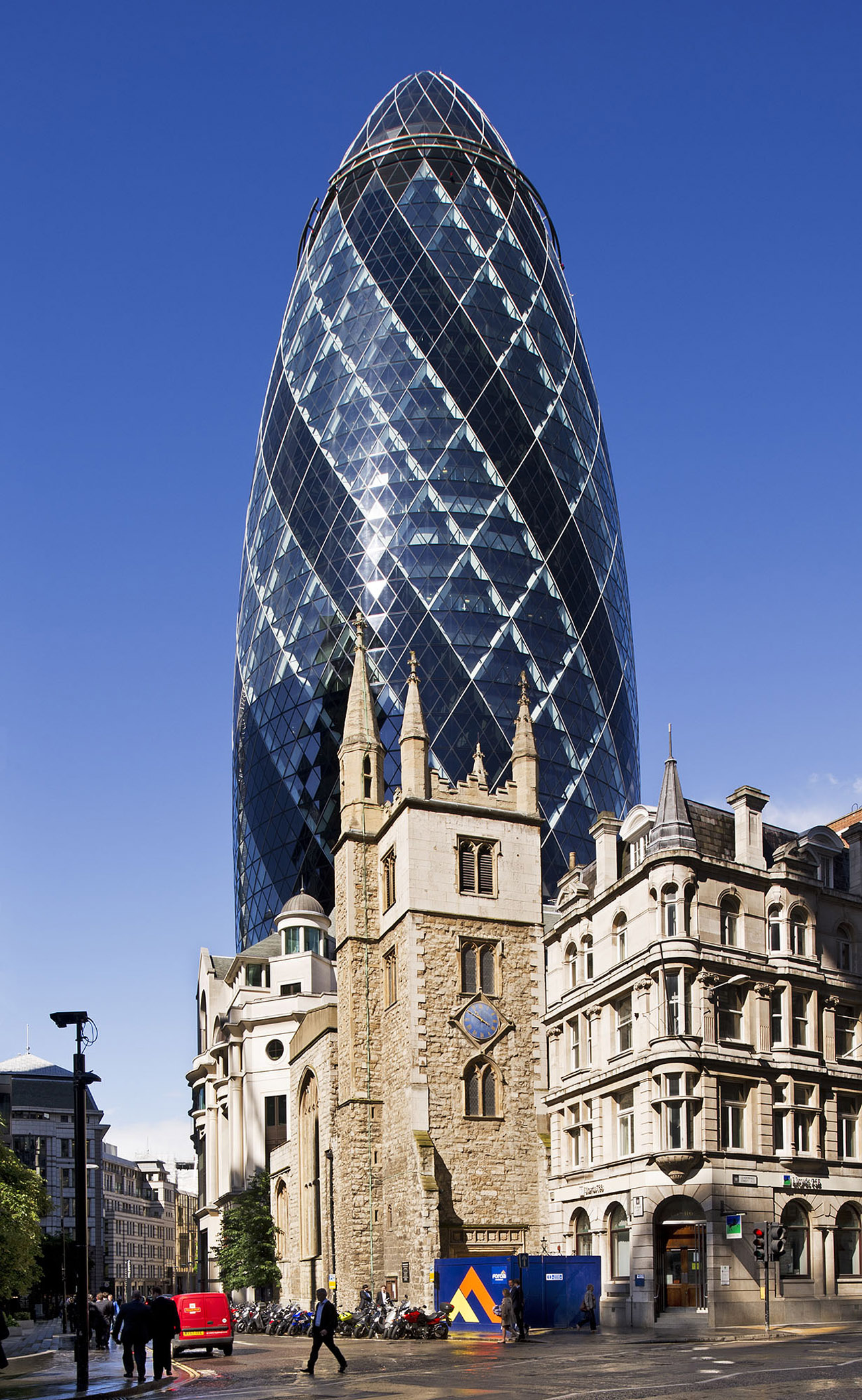
Church of St Andrew Undershaft, St. Mary Axe, City of London, July 11, 2012. Photo © Historic England
Alastair MacIntosh: Lincoln has an amazingly deep and varied history that stretches back over thousands of years. Alongside this really special past, Lincoln is a city that is growing rapidly, in terms of population, economy, commerce, and industry. This makes it really important to make sure that the two cities, old and new Lincoln if you like, cannot only coexist alongside each other, but also shape each other and contribute to their mutual benefit.
So, for example, we have nationally important Roman archaeology across the city, which also sits beneath and potentially constrains new buildings. A heritage inventory is the most important tool we have for understanding the potential for heritage to constrain development, the likelihood of development damaging heritage, and for working out how to balance the two. The Lincoln Heritage Database helps planners and developers to address all of these issues at an early design stage and thus saves everyone time and money.

City of Lincoln, view from castle walls to cathedral. Courtesy of City of Lincoln Council
AS: Who is the inventory system meant for, and who will be using it?
SC: The Greater London Historic Environment Record was originally created as a planning tool, to help identify where archaeological sites were under threat due to development, and to record the finding of new evidence as a result of development. As such it was primarily used by the archaeological advisers in the Greater London Archaeological Advisory Service (GLAAS) to give advice to the London boroughs on planning applications, and also by archaeological contractors. It now covers the whole of London’s historic environment, our interaction with our surroundings from our earliest origins up to the present day, and is also a valuable source of information for academic researchers and the general public wishing to understand more about their local area, and where to find out more.
With the new system we hope to enhance access to users online, particularly to enable them to add new information about sites we don’t currently have on the HER, or improve our knowledge of existing sites. We are particularly keen to give access to our colleagues in the London boroughs who have a lot of information about the built heritage, and its character, which we don’t currently have.
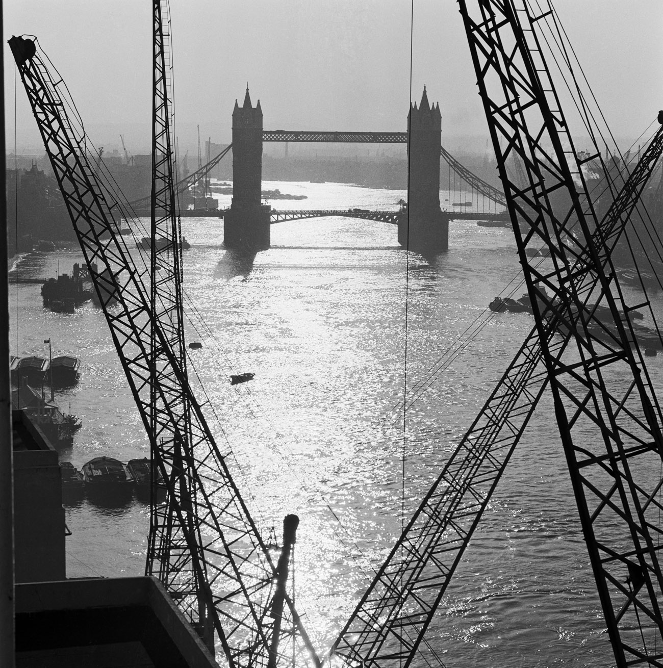
Black and white photo of the Tower Bridge, London, by John Gay, 1946. © Historic England
AM: The Lincoln Heritage Database is held and maintained by the city council on behalf of the people of Lincoln. Information from it is freely available on request, and may be used for any purpose, from academic research, to personal or family history, to commercial archaeological investigations ahead of new development. So it’s no cliché to say that the LHD is for everyone, and everyone uses it, either directly or indirectly. Focusing on the council, the primary users are going to be the city planners, and especially the heritage team.
AS: How will the deployment of Arches through collaboration with the Getty provide advantages over your current system?
SC: We’ve been happy with our current system, which we’ve used for many years now; however, it is issued under a license which makes extending its use across our colleagues in the London boroughs prohibitively expensive. As a result the system as a whole is only accessible from our office in Holborn, although a snapshot of a subset of its data can be viewed on the Heritage Gateway or via the Archaeological Data Service.
The new system we are developing with the Getty and the City of Lincoln is open source and web-based. The use of Arches will enable us to give greater access to users to query our data and interact with us as we work towards widening and improving our record of London’s heritage. Its broader accessibility will also mean that we can work more closely with our colleagues in the London boroughs, and with those recording our historic environment. It will help us change the way we interact with others in the heritage sector, and those interested in the historic environment.
AM: The current LHD system is old—it was created in 1998 as an archaeological database system, and since then it has been tweaked and expanded to add information about historic buildings, events, people, books and reports, and many other aspects of the city’s heritage. It was never designed to represent everything it now contains, and so moving the data to Arches will greatly increase the accessibility and discoverability of the information it contains.
The primary benefit is going to be that it will be a genuinely public-access system. At the moment, even though the data is available to the public, it can only be accessed by application. The new Arches system will place all our heritage information online for everyone to use whenever they want.
AS: The announcement of this collaboration mentions that the data often reveals “complex relationships” among the people and events associated with heritage. Can you provide examples of this in your work?
SC: Putting people back into heritage assets, as it were, is very important—otherwise they are just a collection of bricks, stone, pits, etc. Revealing stories about them, and who lived, worked, and died in them, I think helps people to better understand them, and through that gain a better sense of their local community and hopefully better value their heritage.
To give an example of this: Jane Cakebread, a distant relation of mine, was convicted over 281 times for drunkenness or disorderly conduct and became a bit of a “celebrity” in the late nineteenth century, and her death was reported in The Daily Telegraph of London, The New York Times, and The Barrier Miner, Australia. Jane was eventually committed to the London County Council pauper asylum at Claybury, near Ilford, now a gated community and business park, where she died. Her case was one of those used to persuade the government to pass the Inebriates Act 1989, allowing courts to send alcoholics to special homes for inebriates rather than prison. One example of these homes was St. Veronica’s Retreat for Women, which used to be at Boston House, Chiswick Square—a Grade II listed building which is now private dwellings.
Another drink-related example, and one of my favorites, would be the London Beer Flood of 1814. On the site of what is now the Dominion Theatre, Tottenham Court Road, stood the Horseshoe Brewery owned by Messers. Henry Meux and Company. On the 14th October, one of the wooden fermenting vats, 22-feet high, failed, damaging other vats and releasing an estimated 320,000 gallons of beer to flood the surrounding area, which included the St. Giles rookery, a slum area, associated with poverty and crime, which destroyed or damaged several buildings including the brewery. The event was declared an “act of God” and the company was allowed to reclaim the duty it had already paid on the beer, with the local people affected by the accident receiving nothing. The Horseshoe Brewery was eventually demolished in 1922.

The Angel Inn, Highgate, London, 1874. Photo © Historic England. Situated only five miles from Westminster and the City of London, and the meeting place of several roads, the village of Highgate was a convenient stopover place. It had five inns by 1552, and 21 in 1841. The Angel, an inn from the seventeenth century, has experienced several transformations in its time.

The Angel Inn, Highgate, London, 1882. Photo © Historic England
AM: This is quite a new way of thinking about heritage for us. There are often well-known links between important people in the city’s past, such as major industrialists and the factories and housing that they built, but in most cases the system is not presently set up to record the contributions made by particular people. Likewise, when we refer to an “event” we tend to mean things like archaeological investigations rather than battles or natural disasters. So the ability to record this kind of heritage, the intangible records of people’s lives and what they did, is fundamentally a new capability for us. However, I think it’s going to be something that will quickly become a major part of how we record Lincoln’s past, and I hope that, as well as recording the obvious and well-known relationships, we will start to uncover new ones and bring them to the attention of the wider public.

City of Lincoln, view across west common to Lincoln hillside. Courtesy of City of Lincoln Council
AS: What’s your favorite cultural heritage site in England?
SC: That’s a tricky one. I love the Iron Age hill fort of Maiden Castle for its size (it’s the largest in England) and the effort that must have gone into building it. Then there is the huge Neolithic stone circle around the village of Avebury, better than Stonehenge I think, and I remember watching a children’s TV series in the 1970s set there, which scared the hell out of me as a child!
I think though, I will pick Pevensey Castle. It’s a medieval castle which started as a late-third-century A.D. Roman fort, and was used by William the Conqueror in 1066. It was also used as a prison, the site of a gun battery at the time of the Spanish Armada, and during the Second World War, it was refortified with the alterations made to look like parts of the original castle. Also it is the first castle I can remember being taken to by my parents, and it was the first castle I took my children to as well.
AM: I think there are a couple of good candidates for that actually. Here in Lincoln, we’ve just had some good work ahead of a new building for Lincoln University. When they were planning the build, we worked very closely with them to establish the archaeological potential of the site using a combination of evaluation excavation and archaeological boreholes. The main benefit of the boreholes is that they can provide some information about the deepest archaeology, maybe 12- to 15-feet deep. We learned that the new building was going to be sat straight on top of waterlogged Roman remains, possibly a well-preserved wharf or jetty. While it would have been great to excavate the site, the costs and timescales involved would have seriously compromised the viability of the development. So we worked with the university’s engineers to develop an innovative foundation design that spanned across these remains. Now that may not sound terribly exciting, but it was a big win for both the university, who got to have their new building, and for the most significant archaeology, which we were able to preserve in situ rather than having to excavate it.
Now there were a number of impacts associated with the development that couldn’t be avoided, and so archaeological investigations were necessary. One of these was a 15-feet-deep drainage system, in which we found a number of skeletons which have since been identified as part of a previously unknown Roman cemetery. This was a big issue for the development, and took a good deal of time to deal with appropriately, but through a lot of effort and frantic communication we got the site dealt with and the drainage system in place.
So the site had many different aspects and problems that needed a range of different solutions, which made it incredibly challenging to come up with the right approach—but also terribly rewarding when we did! And it really emphasizes the importance of getting the right information in place at the right time and having the right systems in place to make best use of it.

Battersea Power Station, general view from the northwest, across the River Thames. Photo © Historic England

City of Lincoln, view north along Michaelgate. Courtesy of City of Lincoln Council
Implementation of the two projects in England will take place after the completion of Arches Version 4.0, and are expected to be launched in Lincoln in 2017 and in London in 2018.
The Arches platform was jointly initiated by the Getty Conservation Institute and World Monuments Fund in 2013. For further information on the Arches platform, please visit archesproject.org.

Comments on this post are now closed.